
2021-10-15_00h24m20_16418285

mumu.larandonneuse
Gebruiker GUIDE

Lengte
12,6 km

Max. hoogte
586 m

Positief hoogteverschil
254 m

Km-Effort
16 km

Min. hoogte
470 m

Negatief hoogteverschil
255 m
Boucle
Ja
Datum van aanmaak :
2021-10-14 22:24:20.551
Laatste wijziging :
2022-08-19 13:29:44.916
3h38
Moeilijkheid : Gemakkelijk

Gratisgps-wandelapplicatie
Over ons
Tocht Stappen van 12,6 km beschikbaar op Wallonië, Luik, Sankt Vith. Deze tocht wordt voorgesteld door mumu.larandonneuse.
Beschrijving
Suivre les points-nœuds suivants: 93 > 48 > 29 > 68 > 49 > 80 > 19 > 36 > 69 > 50 > 67 > 9 > 16 > 94 > 93 ou ancien balisage losange rouge.
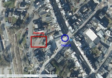
📌& 🅿️ Musée de la bière
🐕 oui
ℹ www.ostbelgien.eu ou l'app Go Ostbelgien
Plaatsbepaling
Land:
Belgium
Regio :
Wallonië
Departement/Provincie :
Luik
Gemeente :
Sankt Vith
Locatie:
Unknown
Vertrek:(Dec)
Vertrek:(UTM)
290741 ; 5575825 (32U) N.
Opmerkingen
Wandeltochten in de omgeving

2022-01-18_14h03m12_st-vith---rodt


Stappen
Gemakkelijk
(1)
Sankt Vith,
Wallonië,
Luik,
Belgium

16,1 km | 19,5 km-effort
4h 26min
Ja

2021-05-17_18h38m48_recht


Stappen
Gemakkelijk
(1)
Sankt Vith,
Wallonië,
Luik,
Belgium

13,3 km | 17,8 km-effort
4h 2min
Ja

Rodt - Chiens de traineau


Stappen
Medium
Sankt Vith,
Wallonië,
Luik,
Belgium

8,4 km | 10,6 km-effort
1h 52min
Ja

20230103 - TOTEMUS Saint-Vith - 6.7 Km


Stappen
Medium
(1)
Sankt Vith,
Wallonië,
Luik,
Belgium

6,7 km | 8,9 km-effort
2h 7min
Ja

20220904 - Rodt 4.7 Km


Stappen
Gemakkelijk
Sankt Vith,
Wallonië,
Luik,
Belgium

4,7 km | 5,9 km-effort
1h 20min
Ja


2022-01-18_13h53m42_st-vith


Stappen
Gemakkelijk
(1)
Sankt Vith,
Wallonië,
Luik,
Belgium

15,9 km | 20 km-effort
4h 34min
Ja

Recht 22 km


Stappen
Gemakkelijk
Sankt Vith,
Wallonië,
Luik,
Belgium

22 km | 29 km-effort
5h 37min
Ja

Rodt - BierMuseum ❄️


Stappen
Medium
Sankt Vith,
Wallonië,
Luik,
Belgium

9,5 km | 11,9 km-effort
2h 20min
Ja


 SityTrail


100% boisé 🌳🌲 Le parcours SityTrail est un peu différent des points-noeuds.